Action Item: Earth!
"What we need today is high-resolution timely geospatial information on a global scale," says Alberto Moreira, director of the Microwaves and Radar Institute at the German Aerospace Center (DLR). "Every minute, something is happening on Earth: it can be deforestation, an earthquake, a tsunami, a calving glacier. It commonly takes hours, even days, until you know the full extent of the damage and where you need to help people."
For Moreira, who will be giving a plenary, "The Future of Spaceborne Radar Remote Sensing," at the 2019 SPIE Remote Sensing symposium in September, the answer lies in observing and mapping our landmasses and oceans as efficiently, effectively, and accurately as possible, using a combination of full-fledged as well as smaller, lightweight radar satellites, interferometry, tomography, data-processing algorithms, and AI.
Radar in space, he notes, is the only technology that can provide geospatial information in a timely manner. "This is the only sensor technology that can map Earth independent of the weather, independent of day and night illumination, and with high resolution," he says.
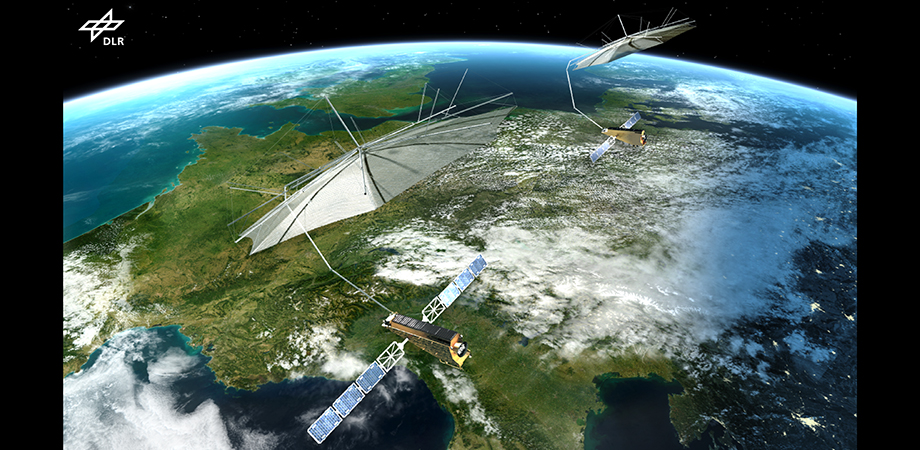
The goal of generating a highly accurate digital elevation model (DEM) of Earth's topography led to TanDEM-X, a dual-satellite project utilizing formation flying and interferometric synthetic-aperture radar (SAR). This resolution-improving technology and satellite mission was initiated and led by Moreira.
Launched in 2010, TanDEM-X generated its DEM with pioneering accuracy, mapping Earth in three dimensions using interferometric processing. "Interferometry is the most accurate measurement that exists; it's the same concept that was used to image that black hole in space for the first time just a few months ago," explains Moreira. Today, TanDEM-X continues to capture three-dimensional images of our landscapes 30 times better than any other dataset available on a global scale. This project also paved the way for Moreira's newest satellite mission, Tandem-L.
TanDEM-X takes a year to map Earth, capturing about a few hundred gigabytes of data per day. That's too slow for our contemporary challenges: climate change, food security, disaster monitoring, megacities, and water shortages. "You cannot catch the dynamic processes that are happening across Earth in a timely fashion now," Moreira explains. "But Tandem-L will be able to map the whole Earth twice a week—we'll be able to see all the changes, as they are happening, every few days. There will be a huge amount of data—10 terabytes a day!"
Moreira explains that he is developing airborne systems to simulate that kind of high-volume data, so that when TanDEM-L is flying five years from now, a cloud-based computer environment will be able to efficiently process data and retrieve information. He says, "We'll be able to capture, for example, forest height and biomass, soil moisture, ground deformation, glacier velocity and volume, and their changes on a global scale."
Making that leap from X to L entails smartening the entire remote-sensing system, using disruptive technologies like a small digital feed array and a large lightweight deployable reflector with 15-m diameter to boost the performance of the radar satellite, as well as enhanced information-processing techniques, like tomography and machine-learning algorithms. "Today, artificial intelligence is only used for the data evaluation, and that area is rapidly improving," says Moreira. "But our goal is to make the whole system intelligent, starting with the sensor and including the entire data flow and satellite operation."
Moreira started his own observational experiences by piloting glider planes in his 20s. "I could discover new areas that I had not seen before, and that's the same thing that we do with remote sensing," he says. "We try to discover our Earth, to understand how our system, Earth, is changing. If we understand that, then we can also better predict Earth's system development. Then," he says, "we can make decisions that actually are very important—for our future and for Earth."
| To listen to Moreira's plenary talk on the state of the art and applications of spaceborne synthetic aperture radar, register to attend SPIE Remote Sensing. |

DEM imagery of Kapstadt, South Africa. Credit: Alberto Moreira
| Enjoy this article? Get similar news in your inbox |
|