Imaging spectrometry in multiple spectral regions for geologic analysis
Spectroscopy is a well-established method of identifying minerals and other geologic materials in the visible to near-IR (VNIR), shortwave-IR (SWIR), and longwave-IR (LWIR) spectral regions.1–4 This approach forms the basis for remote measurements using imaging spectrometry (also called hyperspectral imagery, or HSI), which comprises imagery in up to hundreds of contiguous spectral bands, with a spectrum at each image pixel.5 Hyperspectral data in the VNIR-SWIR has been available for more than 30 years, and analysis of it for geologic applications is considered mature.6 LWIR multispectral data has also been available for a long time7 and is often used in conjunction with VNIR-SWIR data.8–10 LWIR-HSI data, however, has been more difficult to obtain. It is only now becoming broadly available, and provides new capabilities that are just coming into routine use.11 Although typically analyzed in their separate wavelength ranges, there are some examples of using these individual HSI data modes together.12–14 However, fully integrated analysis is still being explored. The research we describe here is part of ongoing full-range HSI data analysis.15–19
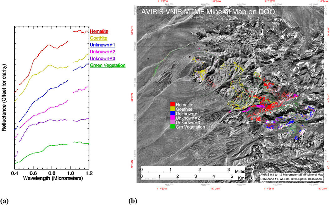
 Our objective was to improve accurate identification and mapping of geologic materials using the complementary information available from the ‘ full’ spectral range (0.4–12μm). Using data from NASA's Airborne Visible/Infrared Imaging Spectrometer (AVIRIS) spanning the VNIR-SWIR, and spatially coincident Hyperspectral Thermal Emission Spectrometer (HyTES) data covering the LWIR, we applied a standardized approach20 to analyzing the HSI data. A model-based atmospheric correction converted AVIRIS VNIR and SWIR HSI radiance data to reflectance.21 The HyTES data was corrected using an LWIR atmospheric compensation model22 followed by temperature/emissivity separation.23 We extracted endmembers (key spectra) from each modal dataset and then performed partial spectral unmixing20 (mixture-tuned-matched filtering, or MTMF) on the individual spectral ranges (see Figures 1–3). AVIRIS directly mapped a variety of specific minerals, while HyTES separated and mapped several igneous rock phases. Some unknown materials require further field verification.


The individual VNIR-SWIR-LWIR results were integrated using class merging, masking, and logical operators. We combined partial unmixing mapping results for individual spectral regions using geologic and spectroscopic directed constraints to reduce variability, reveal additional detail, and clarify associations. For example, close examination of the SWIR mineral spectra and mapping of the carbonate units calcite and dolomite reveals that AVIRIS had some difficulties identifying these materials in shadowed areas. Additionally, HyTES mapping appeared to be less sensitive in low-abundance carbonate areas. Results from both sensors were also negatively affected by spectral mixing between calcite and dolomite. Thus, in some locations materials had the SWIR carbonate spectral features, but no LWIR carbonate features, and vice versa. Combining the two MTMF classifications using a logical OR function (mapping locations where either AVIRIS or HyTES found carbonates) produced a more coherent map of the carbonate units that did not have discontinuities at terrain boundaries. A figure illustrating this concept and additional information are available in a recent paper published elsewhere.19
Taking a similar approach toward mapping individual silicate lithologies and other mineral endmembers, we used geologic context to combine similar materials and to generate mineral assemblages related to hydrothermal alteration (see Figure 4). The variability in similar spectral rock units was combined into individual discrete units using the logical OR operator. We identified alteration assemblages based on the joint occurrence of VNIR-determined minerals (iron oxides) and SWIR-determined muscovite in specific LWIR-defined rock units using a logical AND operator. Muscovite (sericite) alteration was also divided into three types based on joint occurrence of either hematite or goethite in VNIR mapping association. VNIR-mapped goethite areas are also present in SWIR-LWIR mapped carbonates, crosscutting calcite/dolomite boundaries, and possibly indicating additional alteration. We determined certain rock types and areas of skarn (calc-silicates) and silicification solely from their LWIR signatures, and field-verified these. Again, details are available in our recent paper.19

Independent analysis of the VNIR and SWIR AVIRIS and HyTES LWIR hyperspectral data for each spectral range produced complex, information-rich spatial patterns. It was possible to directly relate spectral endmembers and spatial material distributions to physiochemical properties and geologic processes based on specific reflectance absorption features and emissivity minima, and geologic context. However, the integrated mapping approach highlights subtle associations that are not easily observable by mapping the spectrally predominant material in individual ranges. Together, the VNIR-SWIR-LWIR combined modal mapping results lead to improved application-specific characterization and mapping that could not be accomplished using a single spectral range (see Figure 4). The advantage of this approach is that it is possible to tailor the analyses to specific materials of interest. However, this requires the application of subject matter expertise to the individual datasets to combine them in ways that make sense in terms of geologic (or other) context. We are now exploring other integrated analysis approaches for geology and other applications that take advantage of these diverse datasets, while minimizing requirements for additional outside information.15–19
Fred A. Kruse received the PhD in geology from the Colorado School of Mines in 1987. He is currently a research professor, exploring the spatial distribution and spectral character of Earth surface materials. He has been involved in remote sensing research, applications, and teaching for more than 30 years.